Property Information
| Serial Number: 66:552:0079 |
Serial Life: 2017... |
|
|
Total Photos: 2
|
| |
|
|
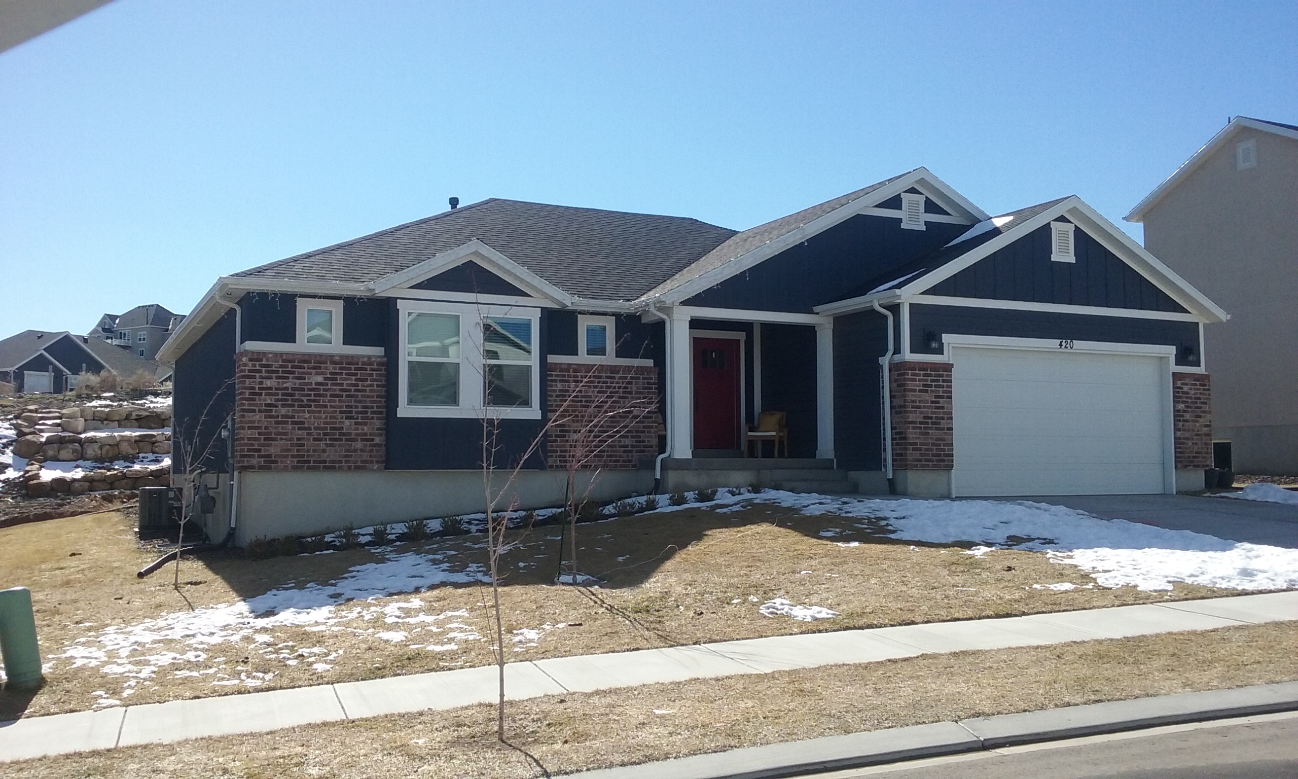
| Property Address: 420 FIRESTONE DR - SANTAQUIN |
|
| Mailing Address: 420 FIRESTONE DR SANTAQUIN, UT 84655 |
|
| Acreage: 0.296497 |
|
| Last Document:
59613-2017
|
|
| Subdivision Map Filing |
|
| Legal Description:
LOT 79, PLAT E, STONE HOLLOW AT SUMMIT RIDGE SUB AREA 0.296 AC. |
|
- Owner Names
- Value History
- Tax History
- Location
- Photos
- Documents
- Aerial Image
| |
----- Real Estate Values ----- |
---Improvements--- |
---Greenbelt--- |
Total |
| Year |
Com |
Res |
Agr |
Tot |
Com |
Res |
Agr |
Tot |
Land |
Homesite |
Tot |
Market Value |
| 2025 |
$0 |
$154,700 |
$0 |
$154,700 |
$0 |
$357,300 |
$0 |
$357,300 |
$0 |
$0 |
$0 |
$512,000 |
| 2024 |
$0 |
$147,300 |
$0 |
$147,300 |
$0 |
$313,000 |
$0 |
$313,000 |
$0 |
$0 |
$0 |
$460,300 |
| 2023 |
$0 |
$147,300 |
$0 |
$147,300 |
$0 |
$335,800 |
$0 |
$335,800 |
$0 |
$0 |
$0 |
$483,100 |
| 2022 |
$0 |
$157,000 |
$0 |
$157,000 |
$0 |
$322,000 |
$0 |
$322,000 |
$0 |
$0 |
$0 |
$479,000 |
| 2021 |
$0 |
$87,200 |
$0 |
$87,200 |
$0 |
$263,700 |
$0 |
$263,700 |
$0 |
$0 |
$0 |
$350,900 |
| 2020 |
$0 |
$72,700 |
$0 |
$72,700 |
$0 |
$253,600 |
$0 |
$253,600 |
$0 |
$0 |
$0 |
$326,300 |
| 2019 |
$0 |
$68,900 |
$0 |
$68,900 |
$0 |
$220,500 |
$0 |
$220,500 |
$0 |
$0 |
$0 |
$289,400 |
| 2018 |
$0 |
$61,200 |
$0 |
$61,200 |
$0 |
$207,000 |
$0 |
$207,000 |
$0 |
$0 |
$0 |
$268,200 |
| 2017 |
$0 |
$61,200 |
$0 |
$61,200 |
$0 |
$0 |
$0 |
$0 |
$0 |
$0 |
$0 |
$61,200 |
| Year |
General Taxes |
Adjustments |
Net Taxes |
Fees |
Payments |
Tax Balance* |
Balance Due |
Tax Area |
| 2026 |
$0.00 |
$0.00 |
$0.00 |
$0.00 |
|
$0.00
|
$0.00 |
190 - SANTAQUIN CITY |
| 2025 |
$2,831.49 |
$0.00 |
$2,831.49 |
$0.00 |
|
$0.00
|
$0.00 |
190 - SANTAQUIN CITY |
| 2024 |
$2,542.28 |
$0.00 |
$2,542.28 |
$0.00 |
|
$0.00
|
$0.00 |
190 - SANTAQUIN CITY |
| 2023 |
$2,659.71 |
$0.00 |
$2,659.71 |
$0.00 |
|
$0.00
|
$0.00 |
190 - SANTAQUIN CITY |
| 2022 |
$2,556.78 |
$0.00 |
$2,556.78 |
$0.00 |
|
$0.00
|
$0.00 |
190 - SANTAQUIN CITY |
| 2021 |
$2,196.86 |
$0.00 |
$2,196.86 |
$0.00 |
|
$0.00
|
$0.00 |
190 - SANTAQUIN CITY |
| 2020 |
$2,108.18 |
$0.00 |
$2,108.18 |
$0.00 |
|
$0.00
|
$0.00 |
190 - SANTAQUIN CITY |
| 2019 |
$1,828.39 |
$0.00 |
$1,828.39 |
$0.00 |
|
$0.00
|
$0.00 |
190 - SANTAQUIN CITY |
| 2018 |
$1,777.05 |
$0.00 |
$1,777.05 |
$0.00 |
|
$0.00
|
$0.00 |
190 - SANTAQUIN CITY |
| 2017 |
$758.94 |
$0.00 |
$758.94 |
$0.00 |
|
$0.00
|
$0.00 |
190 - SANTAQUIN CITY |
|
*The visual representation is a sum of taxes for the year(s) selected and is for reference only and no liability is assumed for any inaccuracies, incorrect data or variations.
|
|
* Note: Original tax amount (Does not include applicable interest and/or fees).
| Entry # |
Date |
Recorded |
Type |
Party1 (Grantor) |
Party2 (Grantee) |
| 161723-2021 |
08/27/2021 |
09/17/2021 |
DECLCOV |
HG 1 UTAH LLC (ET AL) |
WHOM OF INTEREST |
| 23190-2021 |
02/05/2021 |
02/08/2021 |
R DECL |
HG 1 UTAH LLC (ET AL) |
WHOM OF INTEREST |
| 202292-2020 |
12/03/2002 |
12/18/2020 |
AGR |
HG UTAH 1 LLC (ET AL) |
SANTAQUIN CITY CORPORATION |
| 77782-2019 |
08/14/2019 |
08/14/2019 |
ADECCOV |
HG UTAH 1 LLC |
WHOM OF INTEREST |
| 95834-2018 |
10/04/2018 |
10/05/2018 |
COVLAND |
SRC MASTER ASSOCIATION |
WHOM OF INTEREST |
| 86948-2018 |
09/04/2018 |
09/11/2018 |
REC |
COTTONWOOD TITLE INSURANCE AGENCY INC TEE |
SALISBURY DEVELOPERS INC |
| 114576-2017 |
11/20/2017 |
11/20/2017 |
P REC |
COTTONWOOD TITLE INSURANCE AGENCY INC TEE |
SALISBURY DEVELOPERS INC |
| 114575-2017 |
05/14/2017 |
11/20/2017 |
SUB TEE |
M&T BANK |
COTTONWOOD TITLE INSURANCE AGENCY INC SUCTEE |
| 77929-2017 |
08/10/2017 |
08/10/2017 |
REC |
COTTONWOOD TITLE INSURANCE AGENCY INC TEE |
SALISBURY DEVELOPERS INC |
| 59614-2017 |
06/16/2017 |
06/20/2017 |
D TR |
HESTER, JASON & DESIREE |
ACADEMY MORTGAGE CORPORATION |
| 59613-2017 |
06/16/2017 |
06/20/2017 |
WD |
SALISBURY DEVELOPERS INC |
HESTER, JASON & DESIREE |
| 46351-2017 |
05/10/2017 |
05/12/2017 |
D TR |
SALISBURY DEVELOPERS INC |
M & T BANK |
| 19032-2017 |
02/22/2017 |
02/24/2017 |
AF |
SANTAQUIN CITY |
WHOM OF INTEREST |
| 127335-2016 |
12/16/2016 |
12/19/2016 |
D TR |
SALISBURY DEVELOPERS INC |
M&T BANK |
| 123512-2016 |
10/25/2016 |
12/08/2016 |
S PLAT |
SALISBURY DEVELOPERS INC |
STONE HOLLOW AT SUMMIT RIDGE PLAT E |
Main Menu Comments or Concerns on Value/Appraisal - Assessor's Office
Documents/Owner/Parcel information - Recorder's Office
Address Change for Tax Notice
This page was created on 12/10/2025 2:03:58 PM |

