What is PLSS?

The Public Land Survey System (PLSS) is a way of subdividing and describing land in the United States. All lands in the public domain are subject to subdivision by this rectangular system of surveys, which is regulated by the U.S. Department of the Interior, Bureau of Land Management (BLM).
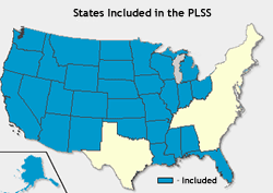
The PLSS is used to divide public domain lands, which are lands owned by the Federal government for the benefit of the citizens of the United States. The original public domain included the land ceded to the Federal Government by the thirteen original States, supplemented with acquisitions from native Indians and foreign powers. It encompasses major portions of the land area of 30 southern and western States. Since the original PLSS surveys were completed, much of the land that was originally part of the public domain has been transferred to private ownership and in some areas the PLSS has been extended, following similar rules of division, into non-public domain areas. PLSS rules of division are explained below. For areas that were once part of the public domain, legal land descriptions are usually written in terms of PLSS descriptions.
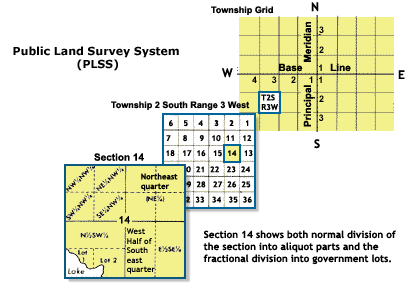
The PLSS typically divides land into 6-mile-square townships, which is the level of information included in the National Atlas. Townships are subdivided into 36 one-mile- square sections. Sections can be further subdivided into quarter sections, quarter-quarter sections, or irregular government lots. Normally, a permanent monument, or marker, is placed at each section corner. Monuments are also placed at quarter-section corners and at other important points, such as the corners of government lots. Today permanent monuments are usually inscribed tablets set on iron rods or in concrete. The original PLSS surveys were often marked by wooden stakes or posts, marked trees, pits, or piles of rock, or other less-permanent markers
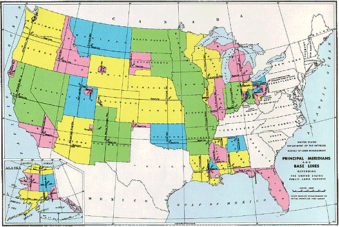
The PLSS actually consists of a series of separate surveys. Most PLSS surveys begin at an initial point, and townships are surveyed north, south, east, and west from that point. The north-south line that runs through the initial point is a true meridian and is called the Principal Meridian. There are 37 Principal Meridians, each is named, and these names are used to distinguish the various surveys. The east-west line that runs through the initial point is called a base line. This line is perpendicular to the Principal Meridian.

Each township is identified with a township and range designation. Township designations indicate the location north or south of the baseline, and range designations indicate the location east or west of the Principal Meridian. For example, a township might be identified as Township 7 North, Range 2 West, which would mean that it was in the 7th tier of townships north of a baseline, and in the 2nd column of townships west of a baseline. A legal land description of a section includes the State, Principal Meridian name, Township and Range designations with directions, and the section number: Nebraska, Sixth Principal Meridian T7N, R2W, sec5.

While the original PLSS surveys were supposed to conform to official procedures, some errors were made due either to honest mistakes or to fraudulent surveys. Existing surveys are considered authoritative, and any new surveys must work from existing corners and surveys, in spite of errors in the original surveys and variations from the ideal. This sometimes results in sections that are far from square, or that contain well over or under 640 acres.
History of the PLSS
General History
Originally proposed by Thomas Jefferson, the PLSS began shortly after the Revolutionary War, when the Federal government became responsible for large areas west of the thirteen original colonies. The government wished both to distribute land to Revolutionary War soldiers in reward for their service, as well as to sell land as a way of raising money for the nation. Before this could happen, the land needed to be surveyed.
The Land Ordinance of 1785 which provided for the systematic survey and monumentation of public domain lands, and the Northwest Ordinance of 1787 which established a rectangular survey system designed to facilitate the transfer of Federal lands to private citizens, were the beginning of the PLSS. Under Congressional mandate, cadastral surveys (surveys of the boundaries of land parcels) of public lands were undertaken to create parcels suitable for disposal by the Government. The extension of the rectangular system of surveys over the public domain has been in progress since 1785, and, where it applies, the PLSS forms the basis for most land transfers and ownership today. The Manual of Instructions for the Survey of the Public Lands Of The United States, 1973 documents current official procedures for PLSS surveys.
Certain lands were excluded from the public domain and were not subject to survey and disposal. These lands include the beds of navigable bodies of water, national installations such as military reservations and national parks, and areas such as land grants that had already passed to private ownership prior to subdivision by the Government. France, Spain, and Mexico all conferred land grants in territory they claimed; many of these grants were confirmed by the U.S Government when the territory in which they were situated was acquired by the United States, and the land was then excluded from the public domain.
History of the PLSS in Utah
The oldest official government survey of the PLSS in the Utah County area of the "territory" of Utah took place in 1856 by Columbus L. Craig (C.L. Craig) under directions and supervision by David H. Burr, Utah's first U.S. Surveyor General. Mr. Craig continued the survey and monumentation of the principle meridian line started by Mr. Burr thru the Salt Lake Valley, initiated from what is termed the "initial point" located at the Southeast Corner of Temple Square. From this principle meridian, Mr. Craig commenced to survey and monument the greater Utah Valley areas involving several of the approximate 36 square mile tracts known today as "townships". It is theorized that Mr. Craig had multiple crews working for him inasmuch as a vast majority of the Utah County valley area was surveyed in less than one year. The C.L. Craig survey consisted of the use of posts (mostly cedar) set every half mile to monument the corners of the individual square mile sections of land. Typically a post would be partially buried in the ground and a mound of earth generated from pits that were dug around the post, would be placed around its base.
Within a relatively short period of time (1870's - 1890's) it was realized that these post monuments would not last and a more durable type of monument was desired. Also, there were areas where C.L. Craig did not survey at all or his survey of the 36 square mile townships were initiated but left incomplete. Contracts were issued to several other government surveyors for retractment of the 1856 surveys, with instructions to utilize marked (chiseled) stones in place of the wood posts where found. It wouldn't be until shortly after the turn of the century (1905 in the Utah Valley Area) that the earliest brass caps would have been used to identify the marked stone locations or complete surveys.
