Property Information
mobile view
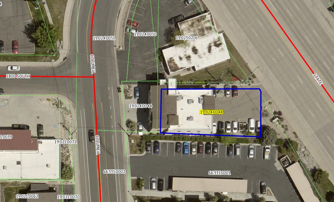
| Serial Number: 19:024:0044 |
Serial Life: 2014... |
|
|
 Total Photos: 6
|
| |
|
|
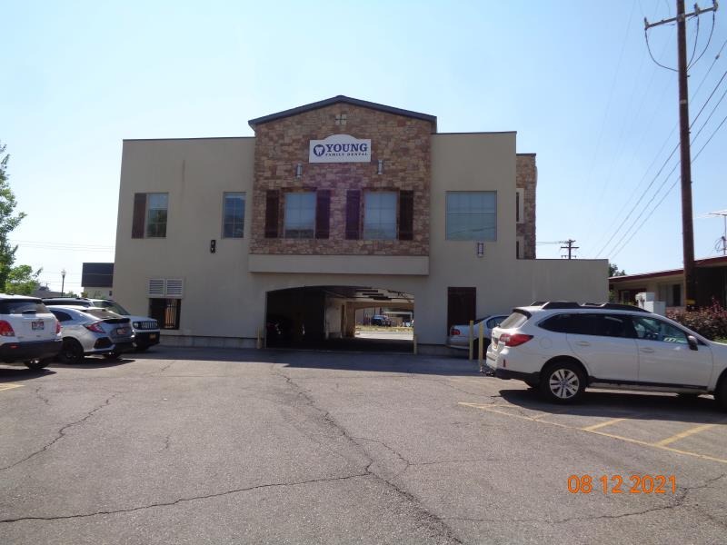
| Property Address: 1834 S STATE - OREM |
|
| Mailing Address: 1463 W 3400 N PLEASANT GROVE, UT 84062-9029 |
|
| Acreage: 0.217639 |
|
| Last Document:
29212-2022
|
|
| Subdivision Map Filing |
|
| Taxing Description:
COM N 1320 FT & W 1239.75 FT FR SE COR. SEC. 26, T6S, R2E, SLB&M.; E 120.72 FT; S 30 DEG 6' 53" E 3.56 FT; S 0 DEG 9' 7" W 55.73 FT; N 87 DEG 33' 53" W 123.35 FT; N 0 DEG 56' 7" E 53.58 FT TO BEG. AREA 0.158 AC. ALSO COM N 0 DEG 36' 53" W 788.64 FT & W 1005.65 FT & S 89 DEG 55' 0" W 236.9 FT & N 0 DEG 43' 0" E 478.4 FT FR SE COR. SEC. 26, T6S, R2E, SLB&M.; N 87 DEG 33' 53" W 38.51 FT; ALONG A CURVE TO L (CHORD BEARS: N 4 DEG 39' 15" W 61.81 FT, RADIUS = 3021.22 FT); N 89 DEG 50' 7" E 44.28 FT; S 0 DEG 43' 0" W 63.38 FT TO BEG. AREA 0.059 AC. TOTAL AREA .218 AC.
*Taxing description NOT FOR LEGAL DOCUMENTS
|
|
- Owner Names
- Value History
- Tax History
- Location
- Photos
- Documents
- Aerial Image
| |
----- Real Estate Values ----- |
---Improvements--- |
---Greenbelt--- |
Total |
| Year |
Com |
Res |
Agr |
Tot |
Com |
Res |
Agr |
Tot |
Land |
Homesite |
Tot |
Market Value |
| 2025 |
$173,700 |
$0 |
$0 |
$173,700 |
$1,629,400 |
$0 |
$0 |
$1,629,400 |
$0 |
$0 |
$0 |
$1,803,100 |
| 2024 |
$170,200 |
$0 |
$0 |
$170,200 |
$1,481,800 |
$0 |
$0 |
$1,481,800 |
$0 |
$0 |
$0 |
$1,652,000 |
| 2023 |
$171,900 |
$0 |
$0 |
$171,900 |
$1,369,800 |
$0 |
$0 |
$1,369,800 |
$0 |
$0 |
$0 |
$1,541,700 |
| 2022 |
$170,200 |
$0 |
$0 |
$170,200 |
$1,246,100 |
$0 |
$0 |
$1,246,100 |
$0 |
$0 |
$0 |
$1,416,300 |
| 2021 |
$168,700 |
$0 |
$0 |
$168,700 |
$1,043,500 |
$0 |
$0 |
$1,043,500 |
$0 |
$0 |
$0 |
$1,212,200 |
| 2020 |
$168,700 |
$0 |
$0 |
$168,700 |
$1,043,500 |
$0 |
$0 |
$1,043,500 |
$0 |
$0 |
$0 |
$1,212,200 |
| 2019 |
$156,000 |
$0 |
$0 |
$156,000 |
$1,044,400 |
$0 |
$0 |
$1,044,400 |
$0 |
$0 |
$0 |
$1,200,400 |
| 2018 |
$148,700 |
$0 |
$0 |
$148,700 |
$982,000 |
$0 |
$0 |
$982,000 |
$0 |
$0 |
$0 |
$1,130,700 |
| 2017 |
$141,600 |
$0 |
$0 |
$141,600 |
$793,600 |
$0 |
$0 |
$793,600 |
$0 |
$0 |
$0 |
$935,200 |
| 2016 |
$134,900 |
$0 |
$0 |
$134,900 |
$838,900 |
$0 |
$0 |
$838,900 |
$0 |
$0 |
$0 |
$973,800 |
| 2015 |
$131,000 |
$0 |
$0 |
$131,000 |
$838,900 |
$0 |
$0 |
$838,900 |
$0 |
$0 |
$0 |
$969,900 |
| 2014 |
$124,900 |
$0 |
$0 |
$124,900 |
$838,900 |
$0 |
$0 |
$838,900 |
$0 |
$0 |
$0 |
$963,800 |
| Year |
General Taxes |
Adjustments |
Net Taxes |
Fees |
Payments |
Tax Balance* |
Balance Due |
Tax Area |
| 2026 |
$0.00 |
$0.00 |
$0.00 |
$0.00 |
|
$0.00
|
$0.00 |
090 - OREM CITY |
| 2025 |
$0.00 |
$0.00 |
$0.00 |
$0.00 |
|
$0.00
|
$0.00 |
090 - OREM CITY |
| 2024 |
$13,510.06 |
$0.00 |
$13,510.06 |
$0.00 |
|
$0.00
|
$0.00 |
090 - OREM CITY |
| 2023 |
$11,730.80 |
$0.00 |
$11,730.80 |
$0.00 |
|
$0.00
|
$0.00 |
090 - OREM CITY |
| 2022 |
$11,123.62 |
$0.00 |
$11,123.62 |
$0.00 |
|
$0.00
|
$0.00 |
090 - OREM CITY |
| 2021 |
$11,428.62 |
$0.00 |
$11,428.62 |
$0.00 |
|
$0.00
|
$0.00 |
090 - OREM CITY |
| 2020 |
$11,628.63 |
$0.00 |
$11,628.63 |
$0.00 |
|
$0.00
|
$0.00 |
090 - OREM CITY |
| 2019 |
$11,073.69 |
$0.00 |
$11,073.69 |
$0.00 |
|
$0.00
|
$0.00 |
090 - OREM CITY |
| 2018 |
$10,916.91 |
$0.00 |
$10,916.91 |
$0.00 |
|
$0.00
|
$0.00 |
090 - OREM CITY |
| 2017 |
$9,270.64 |
$0.00 |
$9,270.64 |
$0.00 |
|
$0.00
|
$0.00 |
090 - OREM CITY |
| 2016 |
$10,468.35 |
$0.00 |
$10,468.35 |
$0.00 |
|
$0.00
|
$0.00 |
090 - OREM CITY |
| 2015 |
$11,024.85 |
$0.00 |
$11,024.85 |
$0.00 |
|
$0.00
|
$0.00 |
090 - OREM CITY |
| 2014 |
$11,005.63 |
$0.00 |
$11,005.63 |
$0.00 |
|
$0.00
|
$0.00 |
090 - OREM CITY |
* Note: Original tax amount (Does not include applicable interest and/or fees).
| Entry # |
Date |
Recorded |
Type |
Party1 (Grantor) |
Party2 (Grantee) |
| 29212-2022 |
03/08/2022 |
03/08/2022 |
CORR AF |
AIRD, NANCY YOUNG TEE (ET AL) |
WHOM OF INTEREST |
| 11563-2022 |
01/26/2022 |
01/27/2022 |
REC |
ALTABANK TEE |
HILLTOP RENTALS LC |
| 9577-2022 |
01/21/2022 |
01/24/2022 |
C D TR |
MANILA CREEK CAPITAL LLC |
UTAH COMMUNITY FEDERAL CREDIT UNION |
| 9544-2022 |
01/21/2022 |
01/24/2022 |
RSUBTEE |
YOUNG, NANCY I TEE (ET AL) |
HILLTOP RENTALS LC |
| 7664-2022 |
01/12/2022 |
01/18/2022 |
D TR |
MANILA CREEK CAPITAL LLC |
UTAH COMMUNITY FEDERAL CREDIT UNION |
| 7663-2022 |
01/17/2022 |
01/18/2022 |
WD |
AIRD, NANCY YOUNG TEE (ET AL) |
MANILA CREEK CAPITAL LLC |
| 7662-2022 |
01/14/2022 |
01/18/2022 |
WD |
HILLTOP RENTALS LC ATA (ET AL) |
AIRD, NANCY YOUNG TEE (ET AL) |
| 82535-2013 |
08/21/2013 |
08/28/2013 |
SP WD |
HILLTOP RENTALS LC |
HILLTOP RENTALS LC |
Main Menu Comments or Concerns on Value/Appraisal - Assessor's Office
Documents/Owner/Parcel information - Recorder's Office
Address Change for Tax Notice
This page was created on 8/9/2025 2:11:10 PM |