Property Information
mobile view
| Serial Number: 08:066:0003 |
Serial Life: 1980... |
|
|
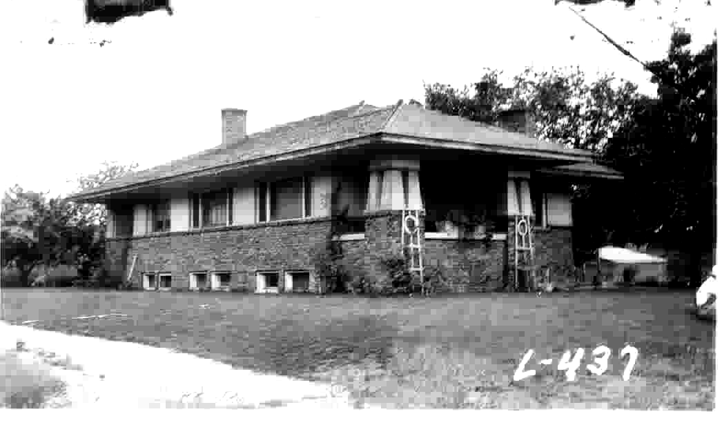
Total Photos: 1
|
| |
|
|
| Property Address: 92 E 300 SOUTH - PAYSON |
|
| Mailing Address: 350 S MAIN ST SPANISH FORK, UT 84660-2408 |
|
| Acreage: 0.16 |
|
| Last Document:
19681-1996
|
|
| Subdivision Map Filing |
|
| Taxing Description:
COM. AT NE COR OF LOT 4, BLK 15, PLAT J, PAYSON CITY SURVEY; W 61.5 FT; S 115 FT; E 61.5 FT; N 115 FT TO BEG. AREA .16 AC.
*Taxing description NOT FOR LEGAL DOCUMENTS
|
|
- Owner Names
- Value History
- Tax History
- Location
- Photos
- Documents
- Aerial Image
| |
----- Real Estate Values ----- |
---Improvements--- |
---Greenbelt--- |
Total |
| Year |
Com |
Res |
Agr |
Tot |
Com |
Res |
Agr |
Tot |
Land |
Homesite |
Tot |
Market Value |
| 1997 |
$0 |
$37,713 |
$0 |
$37,713 |
$0 |
$66,717 |
$0 |
$66,717 |
$0 |
$0 |
$0 |
$104,430 |
| 1996 |
$0 |
$28,575 |
$0 |
$28,575 |
$0 |
$50,551 |
$0 |
$50,551 |
$0 |
$0 |
$0 |
$79,126 |
| 1995 |
$0 |
$25,977 |
$0 |
$25,977 |
$0 |
$50,551 |
$0 |
$50,551 |
$0 |
$0 |
$0 |
$76,528 |
| 1994 |
$0 |
$15,191 |
$0 |
$15,191 |
$0 |
$40,767 |
$0 |
$40,767 |
$0 |
$0 |
$0 |
$55,958 |
| 1993 |
$0 |
$15,191 |
$0 |
$15,191 |
$0 |
$40,767 |
$0 |
$40,767 |
$0 |
$0 |
$0 |
$55,958 |
| 1992 |
$0 |
$13,937 |
$0 |
$13,937 |
$0 |
$37,401 |
$0 |
$37,401 |
$0 |
$0 |
$0 |
$51,338 |
| 1991 |
$0 |
$12,225 |
$0 |
$12,225 |
$0 |
$32,808 |
$0 |
$32,808 |
$0 |
$0 |
$0 |
$45,033 |
| 1990 |
$0 |
$12,225 |
$0 |
$12,225 |
$0 |
$32,808 |
$0 |
$32,808 |
$0 |
$0 |
$0 |
$45,033 |
| 1989 |
$0 |
$12,225 |
$0 |
$12,225 |
$0 |
$32,808 |
$0 |
$32,808 |
$0 |
$0 |
$0 |
$45,033 |
| 1988 |
$0 |
$12,225 |
$0 |
$12,225 |
$0 |
$32,808 |
$0 |
$32,808 |
$0 |
$0 |
$0 |
$45,033 |
| 1987 |
$0 |
$12,225 |
$0 |
$12,225 |
$0 |
$32,600 |
$0 |
$32,600 |
$0 |
$0 |
$0 |
$44,825 |
| 1986 |
$0 |
$12,225 |
$0 |
$12,225 |
$0 |
$32,601 |
$0 |
$32,601 |
$0 |
$0 |
$0 |
$44,826 |
| 1985 |
$0 |
$12,225 |
$0 |
$12,225 |
$0 |
$32,600 |
$0 |
$32,600 |
$0 |
$0 |
$0 |
$44,825 |
| 1984 |
$0 |
$12,350 |
$0 |
$12,350 |
$0 |
$32,933 |
$0 |
$32,933 |
$0 |
$0 |
$0 |
$45,283 |
| Year |
General Taxes |
Adjustments |
Net Taxes |
Fees |
Payments |
Tax Balance* |
Balance Due |
Tax District |
| 1997 |
$659.94 |
($659.94) |
$0.00 |
$0.00 |
|
$0.00
|
$0.00 |
170 - PAYSON CITY |
| 1996 |
$492.59 |
$0.00 |
$492.59 |
$0.00 |
|
$0.00
|
$0.00 |
170 - PAYSON CITY |
| 1995 |
$476.16 |
$0.00 |
$476.16 |
$0.00 |
|
$0.00
|
$0.00 |
170 - PAYSON CITY |
| 1994 |
$535.47 |
$0.00 |
$535.47 |
$0.00 |
|
$0.00
|
$0.00 |
170 - PAYSON CITY |
| 1993 |
$486.31 |
$0.00 |
$486.31 |
$0.00 |
|
$0.00
|
$0.00 |
170 - PAYSON CITY |
| 1992 |
$435.66 |
$0.00 |
$435.66 |
$0.00 |
|
$0.00
|
$0.00 |
170 - PAYSON CITY |
| 1991 |
$402.30 |
$0.00 |
$402.30 |
$0.00 |
|
$0.00
|
$0.00 |
170 - PAYSON CITY |
| 1990 |
$402.79 |
$0.00 |
$402.79 |
$0.00 |
|
$0.00
|
$0.00 |
170 - PAYSON CITY |
| 1989 |
$404.89 |
$0.00 |
$404.89 |
$0.00 |
|
$0.00
|
$0.00 |
170 - PAYSON CITY |
| 1988 |
$404.89 |
$0.00 |
$404.89 |
$0.00 |
|
$0.00
|
$0.00 |
170 - PAYSON CITY |
| 1987 |
$404.18 |
$0.00 |
$404.18 |
$0.00 |
|
$0.00
|
$0.00 |
170 - PAYSON CITY |
| 1986 |
$382.74 |
$0.00 |
$382.74 |
$0.00 |
|
$0.00
|
$0.00 |
170 - PAYSON CITY |
| 1985 |
$372.60 |
$0.00 |
$372.60 |
$0.00 |
|
$0.00
|
$0.00 |
170 - PAYSON CITY |
| 1984 |
$352.12 |
$0.00 |
$352.12 |
$0.00 |
|
$0.00
|
$0.00 |
170 - PAYSON CITY |
* Note: Original tax amount (Does not include applicable interest and/or fees).
| Entry # |
Date |
Recorded |
Type |
Party1 (Grantor) |
Party2 (Grantee) |
| 3187-2015 |
12/04/2014 |
01/14/2015 |
QCD |
UNITED STATES OF AMERICA |
SOUTH UTAH VALLEY ELECTRIC SERVICE DISTRICT |
| 27503-1996 |
04/01/1996 |
04/03/1996 |
REC |
FOXLEY, DOUGLAS S TEE |
SORENSEN, DEBRA |
| 19681-1996 |
03/06/1996 |
03/08/1996 |
WD |
ALLAN, DEBRA J FKA (ET AL) |
BOARD OF EDUCATION OF NEBO SCHOOL DISTRICT (ET AL) |
| 37517-1990 |
10/26/1990 |
11/13/1990 |
TR D |
SORENSEN, DEBRA J |
BEEHIVE CREDIT UNION |
| 37516-1990 |
10/26/1990 |
11/13/1990 |
WD |
BEEHIVE CREDIT UNION AKA (ET AL) |
SORENSEN, DEBRA J |
| 10311-1989 |
03/16/1989 |
04/20/1989 |
REC |
BOYCE, DAVID B SUCTEE |
NOWACKI, ALLEN & LEANN D |
| 10310-1989 |
02/13/1989 |
04/20/1989 |
SUB TEE |
LOMAS MORTGAGE USA INC FKA (ET AL) |
BOYCE, DAVID B SUBTEE |
| 3496-1988 |
01/29/1988 |
02/09/1988 |
TEE D |
MUSSELMAN, D JOHN TEE (ET AL) |
PROVO RAILROAD CREDIT UNION |
| 35752-1987 |
09/14/1987 |
09/21/1987 |
ND |
WARD, CLARK REX SUCTEE |
NOWACKI, N ALLEN & LEANN D |
| 35751-1987 |
09/11/1987 |
09/21/1987 |
SUB TEE |
PROVO RAILROAD CREDIT UNION |
WARD, CLARK REX SUCTEE |
| 30565-1986 |
06/30/1986 |
09/15/1986 |
AS |
FIRST SECURITY REALTY SERVICES CORPORATION FKA (ET AL) |
LOMAS & NETTLETON CO THE |
| 21655-1985 |
07/23/1985 |
08/01/1985 |
TR D |
NOWACKI, N ALLEN & LE ANN D |
PROVO RAILROAD CREDIT UNION |
Main Menu Comments or Concerns on Value/Appraisal - Assessor's Office
Documents/Owner/Parcel information - Recorder's Office
Address Change for Tax Notice
This page was created on 5/22/2024 9:28:23 PM |