Property Information
mobile view
| Serial Number: 41:558:0001 |
Serial Life: 2005... |
|
|

Total Photos: 8
|
| |
|
|
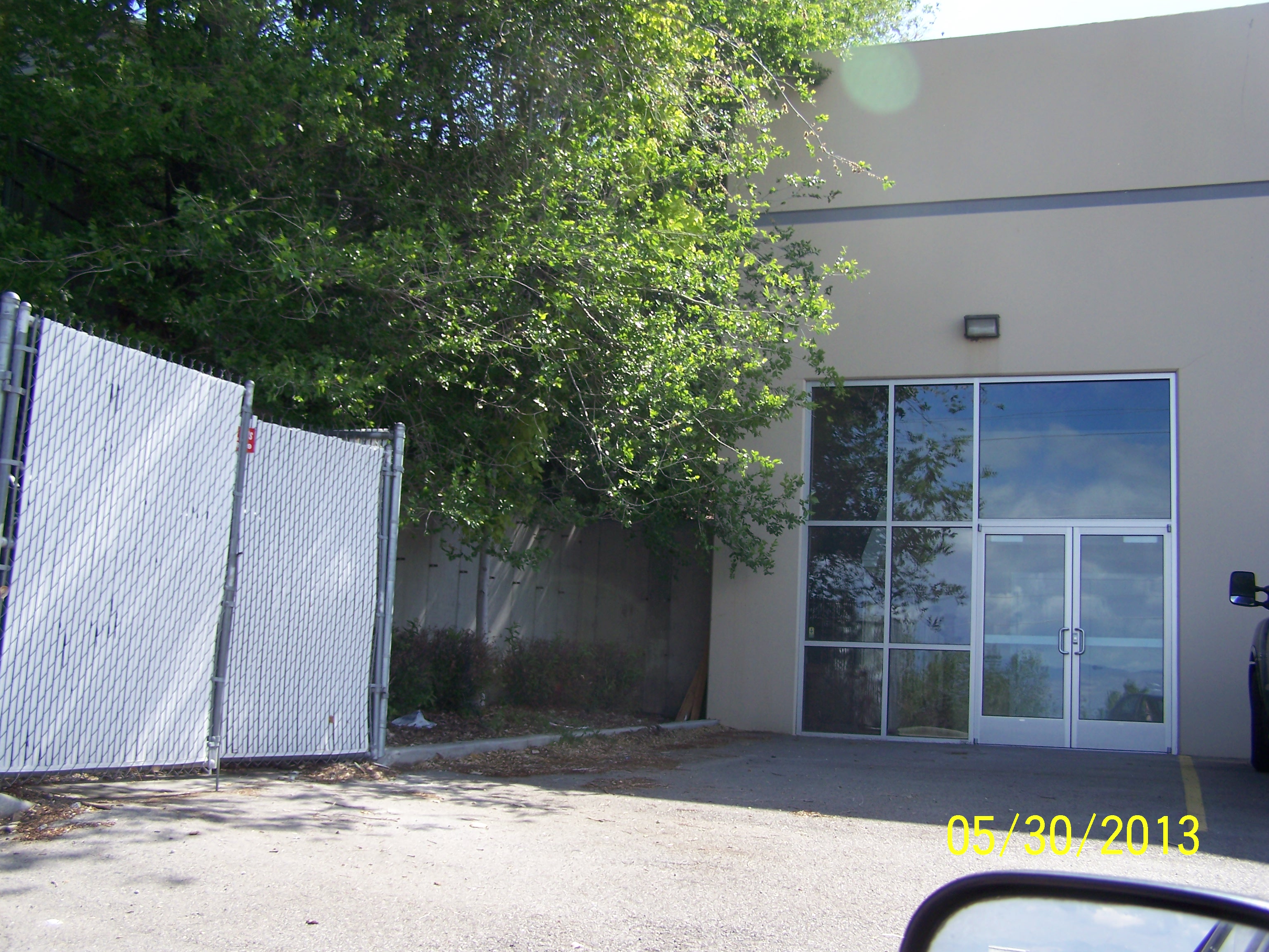
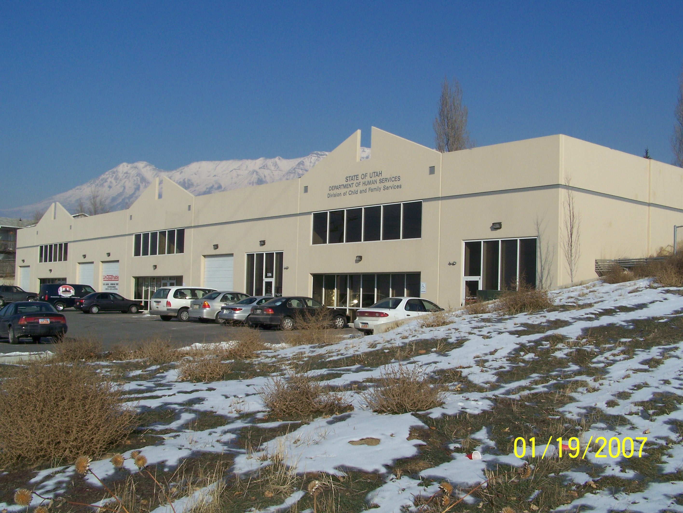
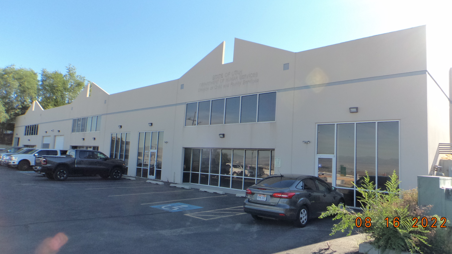
| Property Address: 1126 N 1200 WEST - OREM |
|
| Mailing Address: 1126 N 1200 W OREM, UT 84057-2842 |
|
| Acreage: 0.049 |
|
| Last Document:
35761-2004
|
|
| Subdivision Map Filing |
|
| Taxing Description:
UNIT 1, HAMPTON SQUARE CONDOS. AREA 0.049 AC.
*Taxing description NOT FOR LEGAL DOCUMENTS
|
|
- Owner Names
- Value History
- Tax History
- Location
- Photos
- Documents
- Aerial Image
| |
----- Real Estate Values ----- |
---Improvements--- |
---Greenbelt--- |
Total |
| Year |
Com |
Res |
Agr |
Tot |
Com |
Res |
Agr |
Tot |
Land |
Homesite |
Tot |
Market Value |
| 2024 |
$81,400 |
$0 |
$0 |
$81,400 |
$361,100 |
$0 |
$0 |
$361,100 |
$0 |
$0 |
$0 |
$442,500 |
| 2023 |
$79,800 |
$0 |
$0 |
$79,800 |
$354,000 |
$0 |
$0 |
$354,000 |
$0 |
$0 |
$0 |
$433,800 |
| 2022 |
$79,800 |
$0 |
$0 |
$79,800 |
$230,000 |
$0 |
$0 |
$230,000 |
$0 |
$0 |
$0 |
$309,800 |
| 2021 |
$79,800 |
$0 |
$0 |
$79,800 |
$230,000 |
$0 |
$0 |
$230,000 |
$0 |
$0 |
$0 |
$309,800 |
| 2020 |
$79,800 |
$0 |
$0 |
$79,800 |
$230,000 |
$0 |
$0 |
$230,000 |
$0 |
$0 |
$0 |
$309,800 |
| 2019 |
$69,800 |
$0 |
$0 |
$69,800 |
$240,000 |
$0 |
$0 |
$240,000 |
$0 |
$0 |
$0 |
$309,800 |
| 2018 |
$62,000 |
$0 |
$0 |
$62,000 |
$76,500 |
$0 |
$0 |
$76,500 |
$0 |
$0 |
$0 |
$138,500 |
| 2017 |
$42,200 |
$0 |
$0 |
$42,200 |
$94,400 |
$0 |
$0 |
$94,400 |
$0 |
$0 |
$0 |
$136,600 |
| 2016 |
$42,200 |
$0 |
$0 |
$42,200 |
$94,400 |
$0 |
$0 |
$94,400 |
$0 |
$0 |
$0 |
$136,600 |
| 2015 |
$42,200 |
$0 |
$0 |
$42,200 |
$94,400 |
$0 |
$0 |
$94,400 |
$0 |
$0 |
$0 |
$136,600 |
| 2014 |
$42,200 |
$0 |
$0 |
$42,200 |
$94,400 |
$0 |
$0 |
$94,400 |
$0 |
$0 |
$0 |
$136,600 |
| 2013 |
$42,200 |
$0 |
$0 |
$42,200 |
$94,400 |
$0 |
$0 |
$94,400 |
$0 |
$0 |
$0 |
$136,600 |
| 2012 |
$42,200 |
$0 |
$0 |
$42,200 |
$131,800 |
$0 |
$0 |
$131,800 |
$0 |
$0 |
$0 |
$174,000 |
| 2011 |
$57,100 |
$0 |
$0 |
$57,100 |
$119,900 |
$0 |
$0 |
$119,900 |
$0 |
$0 |
$0 |
$177,000 |
| 2010 |
$62,034 |
$0 |
$0 |
$62,034 |
$126,201 |
$0 |
$0 |
$126,201 |
$0 |
$0 |
$0 |
$188,235 |
| 2009 |
$63,300 |
$0 |
$0 |
$63,300 |
$135,700 |
$0 |
$0 |
$135,700 |
$0 |
$0 |
$0 |
$199,000 |
| 2008 |
$117,000 |
$0 |
$0 |
$117,000 |
$147,500 |
$0 |
$0 |
$147,500 |
$0 |
$0 |
$0 |
$264,500 |
| 2007 |
$111,400 |
$0 |
$0 |
$111,400 |
$140,500 |
$0 |
$0 |
$140,500 |
$0 |
$0 |
$0 |
$251,900 |
| 2006 |
$42,000 |
$0 |
$0 |
$42,000 |
$133,000 |
$0 |
$0 |
$133,000 |
$0 |
$0 |
$0 |
$175,000 |
| 2005 |
$42,000 |
$0 |
$0 |
$42,000 |
$133,000 |
$0 |
$0 |
$133,000 |
$0 |
$0 |
$0 |
$175,000 |
| Year |
General Taxes |
Adjustments |
Net Taxes |
Fees |
Payments |
Tax Balance* |
Balance Due |
Tax District |
| 2025 |
$0.00 |
$0.00 |
$0.00 |
$0.00 |
|
$0.00
|
$0.00 |
090 - OREM CITY |
| 2024 |
$0.00 |
$0.00 |
$0.00 |
$0.00 |
|
$0.00
|
$0.00 |
090 - OREM CITY |
| 2023 |
$3,300.78 |
$0.00 |
$3,300.78 |
$0.00 |
|
$0.00
|
$0.00 |
090 - OREM CITY |
| 2022 |
$2,433.17 |
$0.00 |
$2,433.17 |
$0.00 |
|
$0.00
|
$0.00 |
090 - OREM CITY |
| 2021 |
$2,920.79 |
$0.00 |
$2,920.79 |
$0.00 |
|
$0.00
|
$0.00 |
090 - OREM CITY |
| 2020 |
$2,971.91 |
$0.00 |
$2,971.91 |
$0.00 |
|
$0.00
|
$0.00 |
090 - OREM CITY |
| 2019 |
$2,857.91 |
$0.00 |
$2,857.91 |
$0.00 |
|
$0.00
|
$0.00 |
090 - OREM CITY |
| 2018 |
$1,337.22 |
$0.00 |
$1,337.22 |
$0.00 |
|
$0.00
|
$0.00 |
090 - OREM CITY |
| 2017 |
$1,354.12 |
$0.00 |
$1,354.12 |
$0.00 |
|
$0.00
|
$0.00 |
090 - OREM CITY |
| 2016 |
$1,468.45 |
$0.00 |
$1,468.45 |
$0.00 |
|
$0.00
|
$0.00 |
090 - OREM CITY |
| 2015 |
$1,552.73 |
$0.00 |
$1,552.73 |
$0.00 |
|
$0.00
|
$0.00 |
090 - OREM CITY |
| 2014 |
$1,559.84 |
$0.00 |
$1,559.84 |
$0.00 |
|
$0.00
|
$0.00 |
090 - OREM CITY |
| 2013 |
$1,682.09 |
$0.00 |
$1,682.09 |
$0.00 |
|
$0.00
|
$0.00 |
090 - OREM CITY |
| 2012 |
$2,186.83 |
$0.00 |
$2,186.83 |
$0.00 |
|
$0.00
|
$0.00 |
090 - OREM CITY |
| 2011 |
$2,213.92 |
$0.00 |
$2,213.92 |
$0.00 |
|
$0.00
|
$0.00 |
090 - OREM CITY |
| 2010 |
$2,204.23 |
$0.00 |
$2,204.23 |
$0.00 |
|
$0.00
|
$0.00 |
090 - OREM CITY |
| 2009 |
$2,160.15 |
$0.00 |
$2,160.15 |
$0.00 |
|
$0.00
|
$0.00 |
090 - OREM CITY |
| 2008 |
$2,660.61 |
$0.00 |
$2,660.61 |
$0.00 |
|
$0.00
|
$0.00 |
090 - OREM CITY |
| 2007 |
$2,504.89 |
$0.00 |
$2,504.89 |
$0.00 |
|
$0.00
|
$0.00 |
090 - OREM CITY |
| 2006 |
$1,853.08 |
$0.00 |
$1,853.08 |
$0.00 |
|
$0.00
|
$0.00 |
090 - OREM CITY |
| 2005 |
$2,091.60 |
$0.00 |
$2,091.60 |
$0.00 |
|
$0.00
|
$0.00 |
090 - OREM CITY |
* Note: Original tax amount (Does not include applicable interest and/or fees).
| Entry # |
Date |
Recorded |
Type |
Party1 (Grantor) |
Party2 (Grantee) |
| 111205-2022 |
10/19/2022 |
10/20/2022 |
REC |
WELLS FARGO TRUST COMPANY TEE |
DE BOKETON PROPERTIES LLC |
| 20758-2013 |
02/20/2013 |
03/04/2013 |
REC |
BANK OF AMERICAN FORK TEE |
DE BOKETON PROPERTIES LLC |
| 3744-2013 |
01/07/2013 |
01/11/2013 |
D TR |
DE BOKETON PROPERTIES LLC |
WELLS FARGO BANK |
| 3743-2013 |
01/07/2013 |
01/11/2013 |
WD |
DE BOKETON PROPERTIES LLC AKA (ET AL) |
DE BOKETON PROPERTIES LLC |
| 62030-2012 |
07/20/2012 |
07/26/2012 |
REC |
CENTRAL BANK TEE |
GREENFIELD PROPERTIES LP |
| 91203-2006 |
06/29/2006 |
07/19/2006 |
D TR |
DE BOKETON PROPERTIES LLC |
BANK OF AMERICAN FORK |
| 91202-2006 |
07/18/2006 |
07/19/2006 |
WD |
RLJ PROPERTIES LC |
DE BOKETON POPERTIES (SIC) LLC |
| 61077-2005 |
05/27/2005 |
06/07/2005 |
WD |
CARTER CONSTRUCTION COMPANY |
RLJ PROPERTIES LC |
| 35762-2004 |
03/30/2004 |
03/31/2004 |
DECLCOV |
CARTER CONSTRUCTION COMPANY INC |
WHOM OF INTEREST |
| 35761-2004 |
03/26/2004 |
03/31/2004 |
C PLAT |
CARTER CONST INC |
HAMPTON SQUARE CONDOMINIUMS |
Main Menu Comments or Concerns on Value/Appraisal - Assessor's Office
Documents/Owner/Parcel information - Recorder's Office
Address Change for Tax Notice
This page was created on 5/19/2024 5:21:08 AM |


